
by Colin McDonald | Feb. 11, 2015
The Rio Grande is disappearing. Demand for water is growing as snow packs shrink, rain patterns shift and average temperatures rise faster than they ever have in the past 11,000 years.
Read more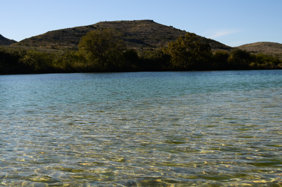
The Devils River flows clear as gin before it enters Lake Amistad and joins the Rio Grande. It’s the cleanest river in Texas, supports endangered fish and birds and is home to plants found nowhere else in the state.
It's less than 70 miles long and is arguably the most protected river in Texas. But despite the 38,000 acres of state natural area and the 160,000 acres of land and conservation easements along its banks that are held by the Texas chapter of The Nature Conservancy, a supporter of this project, the river’s most crucial aspect is not safeguarded.
“If we protect the whole river basin but we have not protected the aquifer, it may not be enough,” said Nature Conservancy biologist John Karges.
Karges explained that as a conservation organization, The Nature Conservancy now has to take a much broader look if it wants to protect places like the Devils River. The old model of putting a fence around the pretty parts is no longer enough. It is an important first step, but there also has to be protection for the broader system.
The Devils is an easy place to see this connection. The river is fed by springs that draw from the Trinity Edwards Aquifer. If that aquifer is drawn down, there would be no springs and the Devils would become a dry arroyo.
The loss would be more than just a difficult-to-access swimming hole.
The only reason the Rio Grande does not remain a salty stream after it leaves Big Bend National Park is because of clear freshwater springs like those on the Devils that flow out of the Trinity Edwards.
The challenge is that it is not understood exactly where and how those springs get their water and what the impact would be from increased pumping from the Trinity Edwards.
We spent Monday exploring the river and its springs with Karges, Taylor Bruecher, a geology graduate student at Sul Ross University who is doing her thesis on the springs of the Devils, and undergraduate research assistant Christine Cosby.
We woke to sub-freezing temperatures and a steaming river. The water from the springs emerges from the ground between 68 and 72 degrees and keeps the pools near them the equivalent of temperature-controlled aquariums. Turtles paddle around just below the surface while schools of big mouth bass and sunfish swim in circles. Mosquito fish dart about and gar lurk in the shadows.
It is a true oasis.
What is known is the springs emerge from the multi-layered limestone of the Trinity Edwards Aquifer, which stretches across and below most of Central and South Texas. Somewhere out there, rainwater is captured and gets to the aquifer.
Where exactly and how the water moves is still a mystery.
Bruecher’s preliminary analysis shows the water leaving the springs is a mix of water that entered the aquifer between several thousand years to less than several decades ago. The springs also seem to be responding to the last decade of drought because the flow of the river has declined by more than a third.
That oscillation is expected, but the pipeline proposals to pump groundwater from near the Devils is what makes Karges concerned. Cities from San Antonio to San Angelo have considered such proposals and there would be no limit on how much they could pump under current regulation. As demand grows and the cost of water increases, there is little chance that pressure will ever go away.
And so the job of protecting the Devils River is now expanded to protecting and understanding the hydrology of an area larger than most states.
Nothing is easy out here.
To comment on this post or ask a question, please visit the expedition's Facebook page.


As they travel, Colin and Erich are taking water samples for the following periodic water quality tests. In partnership with The Meadows Center for Water and the Environment’s Texas Stream Team Program at Texas State University, the results will be added to a public database it helps maintain for research and monitoring water quality.
While making his way to the Gulf of Mexico, Colin will be periodically activating a device that uses satellite technology to share his current location. Use this map to see where he traveled on this day.
| Check-In | Time of Check-In (CST) | Latitude | Longitude |
|---|---|---|---|
| #1 | 11:59 a.m. | 29.88172 | -100.96304 |
| #2 | 1:32 p.m. | 29.8852 | -100.99417 |
| #3 | 2:11 p.m. | 29.89025 | -100.98651 |
| #4 | 3:00 p.m. | 29.89109 | -100.98657 |
| #5 | 6:21 p.m. | 29.88454 | -100.99377 |
To report on and understand the haphazard irrigation system the Rio Grande has become and the changes it is going through, Colin decided the best approach would be to travel the length of the Rio Grande by foot and small boat.
He knew it would give him a unique perspective on a river that few understand. It did require many long days of moving slowly and camping on muddy riverbanks, but Colin likes that sort of thing.
The benefit was it provided access to people who wanted to share their stories and experiences with the Rio Grande. Via Facebook and chance encounters, Colin made instant friends who opened their homes. They provided help from loaning their trucks to their cell phone contact lists to help tell the story of the Rio Grande.
The trip would not have been possible without their help, along with the dedicated assistance of David Lozano, Jason Jones and Daniel Dibona, who drove thousands of miles to get people and boats in place.
Contributors