
by Colin McDonald | Feb. 11, 2015
The Rio Grande is disappearing. Demand for water is growing as snow packs shrink, rain patterns shift and average temperatures rise faster than they ever have in the past 11,000 years.
Read more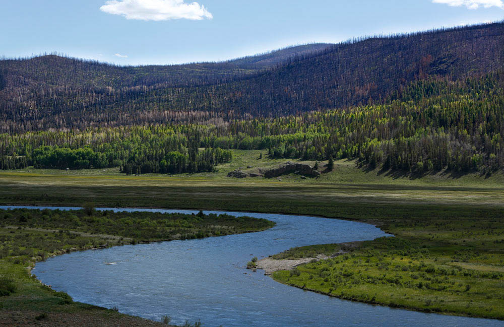
We are starting our expedition on the Rio Grande as the local counties work to set up an early warning system for flash floods and debris flows.
The West Fork Complex fire ripped through these mountains last summer, leaving more than 109,000 acres of charred forest in its wake. With few trees left alive, there is little to hold back the rain and snowmelt. Floods are considered inevitable.
Conditions were ideal for a big burn in June 2013. The forest was packed with trees that had been decimated by beetles and the area was in the middle of the worst drought in generations.
The fire, started by lightning, burned out of control for almost a month. It sent up a smoke plume that rose above 30,000 feet and terrified local residents. The entire tourist season was shot as the highway closed and the Rio Grande ran black.
Now it is running clear, but the rains have been light and the monsoon season has yet to begin.
The parts of the spruce forest that were severely burned could take centuries to recover, said Mike Blakeman of the Rio Grande National Forest.
For Mike, it is personal. On June 26, 1993, he got married. The backdrop for the ceremony was a cliff overlooking the Rio Grande National Forest and the mighty spruce forest. The judge joked the spot was chosen so Mike could not back out.
After the ceremony, family and friends celebrated with a snowball fight. Such snow would never have allowed such a large fire like the West Fork Complex, Mike said.
Now there is no snow in sight except for the tops of mountains and a new forest is taking shape. The grasses and sedges of high mountain meadows and stands of aspen will replace the spruce.
“The fires caused a lot of hardship,” Blakeman said. “But as a person with a natural resource background, I really enjoy watching the recovery.”
To comment on this post or ask a question, please visit the expedition's Facebook page.


While making his way to the Gulf of Mexico, Colin will be periodically activating a device that uses satellite technology to share his current location. Use this map to see where he traveled on this day.
| Check-In | Time of Check-In (CST) | Latitude | Longitude |
|---|---|---|---|
| #1 | 3:05 p.m. | 37.6488 | -107.06197 |

Stony Pass has never been an easy place to get to. The wagon road that was built over it in 1871 was a road in name only. Wagons had to be disassembled and put on the backs of mules to be carried over the crest. The road became famous for the broken wagon parts that lined its side.
The road has not changed much since then. Not that that was a concern for photographer Erich Schlegel and our new head of logistics, Jason Jones. The two of them navigated Erich’s Honda Civic hatchback — nicknamed “El Burrito” because it is small and hauls as much as a burro — through the streams and over the boulders like it was in a truck commercial. I sat in the back, held on and tried not to watch. The result was they cut the 21-mile hike from our campsite at Thirty-Mile Campground to the top of Stony Pass down to 10 miles.
This area did not burn in the West Fork Complex Fire. The higher we climbed, the fewer dead spruce we saw. At about 11,500 feet, the trees were healthy, the river was running clear and if it were not for the dozen motorcycles, 4-wheelers and Jeeps that passed us as we walked, we could have been back in the 1870s.
To comment on this post or ask a question, please visit the expedition's Facebook page.


As they travel, Colin and Erich are taking water samples for the following periodic water quality tests. In partnership with The Meadows Center for Water and the Environment’s Texas Stream Team Program at Texas State University, the results will be added to a public database it helps maintain for research and monitoring water quality.
While making his way to the Gulf of Mexico, Colin will be periodically activating a device that uses satellite technology to share his current location. Use this map to see where he traveled on this day.
| Check-In | Time of Check-In (CST) | Latitude | Longitude |
|---|---|---|---|
| #1 | 6:57 a.m. | 37.72227 | -107.26004 |
| #2 | 12:45 p.m. | 37.7495 | -107.42831 |
| #3 | 3:25 p.m. | 37.76556 | -107.46811 |
| #4 | 7:41 p.m. | 37.79448 | -107.54839 |

Stony Pass has the distinction of being the headwaters for the Rio Grande. If we went any farther west we would be in the watershed of the Colorado River. So this is where we are going to turn around and start our journey to the Gulf of Mexico.
At more than 12,650 feet, the pass is high enough to make a person from sea level nauseous. The pass stays snowy well into July. Up here, the river is so small you can jump over it without getting your feet wet.
These snowfields are the biggest reservoirs for the entire river. The amount of snow in the mountains and how fast it melts determines what kind of irrigation season farmers 600 miles away in El Paso will have — and how much walking we will have to do.
For fun, I’m taking a few ounces of snow to carry with me to the coast. Since the completion of Elephant Butte Dam in New Mexico in 1916, and the expanded irrigation and management of the river it allowed, practically no water from the Rocky Mountains has made it to the Gulf of Mexico via the Rio Grande.
Snowmelt on the west side of Stony Pass that drains into the Colorado doesn’t have much chance of reaching the Gulf of California, either. All the snow we see here is most likely going to evaporate from reservoirs, lawns and farm fields well before it reaches either coast.
Our goal is to find out what going dry means for the river and the people and places that depend on it.
It’s going to be hot and dry, but for now it’s cool and wet, so we are going to enjoy it.
To comment on this post or ask a question, please visit the expedition's Facebook page.


As they travel, Colin and Erich are taking water samples for the following periodic water quality tests. In partnership with The Meadows Center for Water and the Environment’s Texas Stream Team Program at Texas State University, the results will be added to a public database it helps maintain for research and monitoring water quality.
While making his way to the Gulf of Mexico, Colin will be periodically activating a device that uses satellite technology to share his current location. Use this map to see where he traveled on this day.
| Check-In | Time of Check-In (CST) | Latitude | Longitude |
|---|---|---|---|
| #1 | 10:03 a.m. | 37.79054 | -107.55287 |
| #2 | 1:32 p.m. | 37.7572 | -107.46434 |
| #3 | 2:34 p.m. | 37.7499 | -107.42715 |
| #4 | 7:45 p.m. | 37.72226 | -107.2599 |
| #5 | 9:17 p.m. | 37.72226 | -107.25995 |
To report on and understand the haphazard irrigation system the Rio Grande has become and the changes it is going through, Colin decided the best approach would be to travel the length of the Rio Grande by foot and small boat.
He knew it would give him a unique perspective on a river that few understand. It did require many long days of moving slowly and camping on muddy riverbanks, but Colin likes that sort of thing.
The benefit was it provided access to people who wanted to share their stories and experiences with the Rio Grande. Via Facebook and chance encounters, Colin made instant friends who opened their homes. They provided help from loaning their trucks to their cell phone contact lists to help tell the story of the Rio Grande.
The trip would not have been possible without their help, along with the dedicated assistance of David Lozano, Jason Jones and Daniel Dibona, who drove thousands of miles to get people and boats in place.
Contributors