
by Colin McDonald | Feb. 11, 2015
The Rio Grande is disappearing. Demand for water is growing as snow packs shrink, rain patterns shift and average temperatures rise faster than they ever have in the past 11,000 years.
Read more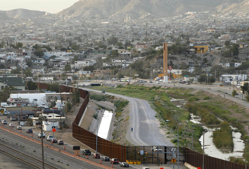
Today we started following a different Rio Grande.
The day began at the American Dam, which was diverting all of the water in the river into the American Canal.
Some of this water was from the trickle that formed because of the recent monsoon rains, but most was the effluent from one of El Paso’s sewer treatment plants.
I then walked past the International Dam, which is in place to divert the water owed to Mexico by treaty during the irrigation season. The drought reduced this year's irrigation season to just more than a month long and it ended months ago.
The end result of the two dams is that I was now traversing the second headwaters of the Rio Grande. Instead of being born from snowfields at Stony Pass, this Rio Grande is born from small springs and the return flow for sewer plants and farm fields.
At best, the river is going to be a stream from here until it is joined by the Rio Conchos flowing out of Mexico some 300 miles downstream.
This is also the start of the Rio Grande marking 1,200 miles of the border between the United States and Mexico. As I walked along the fence built to stop illegal immigrants, contractors in pickups drove slowly along looking for where the metal mesh of the fence needed to be welded back together. Cutting the fence appears to be the most popular way to sneak into the U.S. on this section of the border.
Border Patrol agents told me the fence does not stop people, but it does a good job of slowing them down. In most places the fence is right in front of the cement-lined American Canal. It’s like a moat and every year half a dozen people drown in it as they try to swim across. There are even signs warning people not to enter the swiftly flowing water.
I passed 37 Border Patrol agents in white trucks watching Mexico as I walked 17 miles on the levee of the U.S. side of the Rio Grande.
On the Mexican side, where many people had the day off thanks to the national holiday celebrating Mexican Independence, I saw people riding bikes, running and walking along the river. The cement riverbed was a park on that side of the river.
The agents on the U.S. side were friendly. They pointed out good places to get photos of the river. One gave me a chilled nectarine and told me how burrowing owls used to live along the edge of the levee and that stray dogs were common.
Now that the water is gone, so are they.
On Friday, I met with John Balliew, the CEO of El Paso Water Utilities, to learn about how the utility is dealing with a shrinking Rio Grande. The short answer is it's preparing a massive public outreach campaign to convince residents that drinking treated sewer water can be a safe and affordable option. It’s living toilet to tap. It's how astronauts on the International Space Station get their water.
The method El Paso is proposing would quadruple filter the water so that almost nothing but individual molecules of water would be able to pass through. It won't get everything, but it will come very, very close.
And the city does not have much choice if it wants to have more water. El Paso gets half of its water supply from the Rio Grande. The rest comes from aquifers that have been filled mostly with water filtering in from the river.
This is not a new issue for El Paso. The river has never been a reliable source and in 1985 the city started injecting treated sewage into the aquifer to help augment the supply. It was also a cheaper alternative to piping the water back to the Rio Grande.
In 2007, the city partnered with the U.S. military and built a massive desalination plant to mine brackish groundwater. Now it is looking at ways to inject the flows of the Rio Grande, whatever they are and whenever they come, into the aquifer so they can be stored. Nothing will get by El Paso.
“We need to be prepared to have no water in the Rio Grande,” Balliew said.
I walked along the future today.
To comment on this post or ask a question, please visit the expedition's Facebook page.


As they travel, Colin and Erich are taking water samples for the following periodic water quality tests. In partnership with The Meadows Center for Water and the Environment’s Texas Stream Team Program at Texas State University, the results will be added to a public database it helps maintain for research and monitoring water quality.
While making his way to the Gulf of Mexico, Colin will be periodically activating a device that uses satellite technology to share his current location. Use this map to see where he traveled on this day.
| Check-In | Time of Check-In (CST) | Latitude | Longitude |
|---|---|---|---|
| #1 | 8:07 a.m. | 31.78399 | -106.52625 |
| #2 | 8:23 a.m. | 31.78169 | -106.52789 |
| #3 | 8:54 a.m. | 31.76665 | -106.51134 |
| #4 | 9:31 a.m. | 31.74984 | -106.49069 |
| #5 | 10:15 a.m. | 31.76066 | -106.46539 |
| #6 | 10:35 a.m. | 31.76489 | -106.45317 |
| #7 | 11:52 a.m. | 31.74221 | -106.39795 |
| #8 | 12:53 p.m. | 31.70994 | -106.3665 |
| #9 | 1:41 p.m. | 31.68178 | -106.34174 |
To report on and understand the haphazard irrigation system the Rio Grande has become and the changes it is going through, Colin decided the best approach would be to travel the length of the Rio Grande by foot and small boat.
He knew it would give him a unique perspective on a river that few understand. It did require many long days of moving slowly and camping on muddy riverbanks, but Colin likes that sort of thing.
The benefit was it provided access to people who wanted to share their stories and experiences with the Rio Grande. Via Facebook and chance encounters, Colin made instant friends who opened their homes. They provided help from loaning their trucks to their cell phone contact lists to help tell the story of the Rio Grande.
The trip would not have been possible without their help, along with the dedicated assistance of David Lozano, Jason Jones and Daniel Dibona, who drove thousands of miles to get people and boats in place.
Contributors